


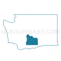
E Moxee Voting District, Yakima County, Washington
About
Outline

Summary
| Unique Area Identifier | 690213 |
| Name | E Moxee Voting District |
| County | Yakima County |
| State | Washington |
| Area (square miles) | 116.67 |
| Land Area (square miles) | 116.67 |
| Water Area (square miles) | 0.00 |
| % of Land Area | 100.00 |
| % of Water Area | 0.00 |
| Latitude of the Internal Point | 46.51954210 |
| Longtitude of the Internal Point | -120.08252250 |
Maps

Graphs
Select a template below for downloading or customizing gragh for E Moxee Voting District, Yakima County, Washington


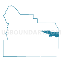
Neighbors
Neighoring Voting District (by Name) Neighboring Voting District on the Map
- Columbia Voting District, Benton County, WA
- Liberty Voting District, Yakima County, WA
- Moxee Voting District, Yakima County, WA
- Moxee Rural Voting District, Yakima County, WA
- N Holland Voting District, Yakima County, WA
- N Sunnyside Voting District, Yakima County, WA
- Outlook Voting District, Yakima County, WA
- Rattlesnake Voting District, Benton County, WA
- Wanapum Voting District, Yakima County, WA
Top 10 Neighboring County Subdivision (by Population) Neighboring County Subdivision on the Map
- Yakima CCD, Yakima County, WA (139,936)
- Sunnyside CCD, Yakima County, WA (51,665)
- Northwest Benton CCD, Benton County, WA (13,622)
- Northeast Yakima CCD, Yakima County, WA (9,106)
Top 10 Neighboring Place (by Population) Neighboring Place on the Map
Top 10 Neighboring Unified School District (by Population) Neighboring Unified School District on the Map
- Richland School District, WA (62,323)
- Sunnyside School District, WA (24,342)
- Selah School District, WA (18,675)
- East Valley School District (Yakima), WA (15,549)
- Prosser School District, WA (12,996)
- Granger School District, WA (5,751)
- Zillah School District, WA (5,123)
Top 10 Neighboring State Legislative District Lower Chamber (by Population) Neighboring State Legislative District Lower Chamber on the Map
- State House District 8, WA (149,474)
- State House District 13, WA (143,750)
- State House District 15, WA (132,788)
Top 10 Neighboring State Legislative District Upper Chamber (by Population) Neighboring State Legislative District Upper Chamber on the Map
- State Senate District 8, WA (149,474)
- State Senate District 13, WA (143,750)
- State Senate District 15, WA (132,788)
Top 10 Neighboring 111th Congressional District (by Population) Neighboring 111th Congressional District on the Map
Top 10 Neighboring Census Tract (by Population) Neighboring Census Tract on the Map
- Census Tract 22, Yakima County, WA (7,745)
- Census Tract 18, Yakima County, WA (7,140)
- Census Tract 118, Benton County, WA (6,546)
- Census Tract 17.02, Yakima County, WA (6,023)
- Census Tract 17.01, Yakima County, WA (3,083)
- Census Tract 16.01, Yakima County, WA (2,413)
- Census Tract 21.01, Yakima County, WA (1,950)
Top 10 Neighboring 5-Digit ZIP Code Tabulation Area (by Population) Neighboring 5-Digit ZIP Code Tabulation Area on the Map
- 98901, WA (30,169)
- 98944, WA (22,014)
- 99350, WA (12,979)
- 98953, WA (6,681)
- 98936, WA (5,872)
- 98938, WA (2,177)